THE EVOLUTION OF FLOOD CONTROL


The devastating impact of Hurricane Hazel in 1954 was a mobilizing force in bringing a regional approach to flood control and water management in Ontario.

A more coordinated approach between conservation authorities, local municipalities and the province took form after Hazel, and today these organizations play a significant role in the protection of life and property from natural hazards, such as flooding.

After Hazel, the provincial government amended the Conservation Authorities Act to enable an authority to acquire lands for recreation and conservation purposes and to regulate that land for the safety of the community.


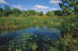
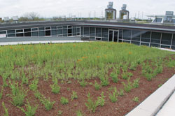
Forests and wetlands are protected and more trees are planted. They help to store runoff to reduce flooding.

In 1959, a comprehensive Plan for Flood Control and Water Conservation was finalized by the Metropolitan Toronto and Region Conservation Authority ( MTRCA ). It included the proposed development of large dams and major flood control channels, and the initiation of an erosion control program. In addition, 7,200 acres of land were identified for acquisition.

In 1960, the Lands Acquisition Program was implemented as the initial stage in the MTRCA flood control plan. The intent of this program was to transfer the liability of floodplain land from private hands to the authority and to acquire lands necessary for the construction of flood protection works.

The second stage of the MTRCA flood control plan, was the Flood Control Works Program. The intent of this program was to construct as many structures that were necessary to control flooding. The works consisted of dams, reservoirs, channel improvements and other infrastructure.


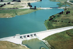
Flood control dams store water during a flood, and release it more gradually after the flood has passed.

While some of the initial flood protection planning and implementation began within the MTRCA, as one of the most directly affected conservation authority’s by Hurricane Hazel, similar flood protection activities also began soon afterward within other conservation authorities throughout the province.

The development and implementation of new provincial flood plain regulations acted as a complementary third stage in obtaining the goals of the flood control plan. These regulations allowed for the control of future development and inappropriate land use activities in flood-hazard areas. As well, a Flood Forecasting and Warning Program was designed to monitor watershed conditions including snow, precipitation and flows, as well as to issue flood alerts to municipalities when conditions warranted.


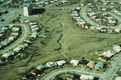
Regulations restrict new development in floodplains, allowing rivers to flow naturally and reducing the risk to people and their property during flooding.

Conservation Authorities Act
The Conservation Authorities Act was legislated by the provincial government in 1946 in response to the concern by agricultural, naturalist and sportsmen's groups, that the renewable natural resources of the province were in an unhealthy state. Although the responsibility for managing natural resources lay with the province, the scale of erosion and water problems was such that it required a new approach, and when a number of municipal councils agreed to become involved, this spirit of cooperation led to the passage of the Conservation Authorities Act in 1946. Three fundamental concepts of this new approach were embodied in the Act: local initiative, cost sharing and watershed jurisdiction. The Conservation Authorities Act provided the means by which the province and the municipalities of Ontario could join together to form a conservation authority within a specified area—the watershed—to undertake programs for natural resource management. Today there are 36 conservation authorities in Ontario.

It is only possible to achieve the many goals in managing Ontario's watershed resources, with the help and cooperation of conservation authorites' many partners and stakeholders; foresters, engineers, ecologists, geologists, economists, municipal members, volunteers, farmers, developers, educators and citizens just to name a few.

Over time, conservation authorities have become involved in a wide range of activities and responsibilities, depending on the environmental concerns of local residents, member municipalities and the province. Each conservation authority's watershed management program is geared to its local needs and, therefore, the authority may or may not implement all programs.

Conservation Authorities' Range of Program Development
  • Flood Control
  • Erosion Control
  • Watershed Strategies
  • Floodplain Management
  • Flood Warning
  • Great Lakes Shoreline Management
  • Provincial Water Quality Monitoring
  • Ground Water Monitoring
  • Streamflow Monitoring
  • Urban Stormwater Management
  • Waterfront Development Flow
  • Wetlands
  • Water Supply/Low Flow Augmentation
  • Community Relations
  • Niagara Escarpment
  • Outdoor Recreation
  • Fish and Wildlife Management
  • Private Land Extension
    -reforestation
    -soil erosion/sedimentation
  • Windbreaks and Shelterbelts
  • Forest Management
  • Fish and Wildlife Habitat
  • Rural Drainage
  • Heritage Conservation
  • Network Hydro Generation
  • Tourism
  • Municipal Plan Review
  • Natural Area Preservation
  • Environmentally Sensitive Areas

Ontario's conservation authorities have achieved an enviable record in wetland protection and management, conservation education, provision of local and regional recreational opportunities, forest management and heritage conservation.

Several flood control facilities were significantly upgraded or built following Hurricane Hazel. Gauging stations became operational and a rainfall observer network was organized, providing the ability to forecast and warn against potential flooding in the area. Operational practices were also designed to respond immediately to changing conditions.

There are three important components to flood management and forecasting in which the conservation authorities are responsible:

Prevention. Informing planners and the general public about the risks of flooding to promote proper land use planning, preventing people from living and/or working in flood-prone areas. Conservation authorities are responsible for predicting flows and water levels within their watersheds, operating flood control structures, such as dams and disseminating flood warnings to local municipalities and agencies.

Protection. In order to protect against flooding, conservation authorities have constructed and maintain protective infrastructure, such as dams and dykes, or purchase lands located in hazardous areas. Stream gauges, weather stations, surveys of snow conditions, meteorological forecasts and computer models are used to forecast potential floods.

Emergency Preparedness and Response. Conservation authorities work with the Ministry of Natural Resources (MNR) to provide advice to municipalities for the preparation of flood contingency plans and to provide advice during the emergency response process. In Ontario, conservation authorities, and the MNR are responsible for forecasting where and when flooding is likely to occur and issuing flood alerts and warnings to local municipalities, the media, police and school boards. To facilitate this activity, conservation authorities and the MNR work closely with Environment Canada, Meteorological Services, who provide the weather information necessary to make the flood forecasting systems function effectively.

These advance warnings allow municipalities and other government agencies to put emergency response plans into operation, to evacuate communities and remove portable property from flood-susceptible areas. Advance warnings also notifies the public of developing or ongoing unsafe river and lake conditions, and allows them to take precautions.

There are four different flood messages:

FLOOD ADVISORY: notifies that the potential for flooding exists within specific watercourses and municipalities.
FLOOD WARNING: notifies that flooding is imminent or occurring within specific watercourses and municipalities.
FLOOD SAFETY BULLETIN: notifies that unsafe lake, river and channel conditions exist.
WATERSHED CONDITIONS BULLETINS: notifies of anticipated watershed conditions.

In Ontario, the flood risk area is defined by the flooding hazard limit. Depending on location in the province, the flooding hazard limit is determined by the 100-year peak flow, a regional storm or the highest observed flood. In some communities, the two-zone approach is used, with a floodway and flood fringe being designated. Ontario has over 270 communities that are 'designated flood areas'. Is your property in a 'designated area' that is subject to recurrent and severe flooding? Find out at www.ec.gc.ca/water/en/manage/flood/e_ont.htm

[Top]

"The first barrier to the contamination of drinking water involves protecting the sources of drinking water."

— Justice Dennis O'Connor, Walkerton Inquiry 2002

Water quality initiatives have become more prominent with the water contamination in Walkerton, Ontario. Reports following the Walkerton tragedy, included recommendations made to the government that conservation authorities take the lead in source protection planning — the government has agreed to implement all of the Walkerton Inquiry recommendations.

Water is critical to all aspects of our lives and it is important that we ensure there is a safe and reliable source of water for all our uses — now and in the future. Our drinking water comes from lakes, rivers, streams or underground sources (aquifers) located across the province. All of these sources of water are linked in a watershed through the water cycle.

Efforts are ongoing to develop source protection plans for each watershed in the province. This includes managing Ontario's rivers and other water courses on a watershed basis where we realize that everything is interconnected; the human and natural impacts affect the water quality.

Conservation authorities are the only watershed management agencies in Ontario that are organized on a watershed basis. Since Hazel, the role of conservation authorities has grown to include the protection, management and restoration of Ontario's waters, woodlands, wetlands and natural habitat; the development of programs that will protect life and property from natural hazards such as flooding and erosion; and the delivery of environmental education to the public to ensure our environment is protected for future generations.


"Green roofs" are a new idea of growing plants in soil on
flat rooftops, which store rainfall, serving to reduce floods. York University.
[Top]

Facts at a Glance

If you are interested in getting involved in environmental initiatives in your community, please contact your local conservation authority below.


Ontario's 36 Conservation Authorities

AUSABLE BAYFIELD CONSERVATION AUTHORITY
71108 Morrison Line, RR # 3, Exeter, ON, NOM 1S5
1-888-286-2610 or (519) 235-2610 FAX (519) 235-1963
E-mail:
info@abca.on.ca

CATARAQUI REGION CONSERVATION AUTHORITY
Box 160, 1641 Perth Road, Glenburnie, ON K0H 1S0
(613) 546-4228 FAX (613) 547-6474
E-mail: crca@cataraquiregion.on.ca

CATFISH CREEK CONSERVATION AUTHORITY
R. R. #5, Aylmer, ON N5H 2R4
(519) 773-9037 FAX (519) 765-1489
E-mail: ccca@execulink.com

CENTRAL LAKE ONTARIO CONSERVATION AUTHORITY
100 Whiting Avenue, Oshawa, ON L1H 3T3
(905) 579-0411 FAX: (905) 579-0994
E-mail: mail@cloca.com

CONSERVATION HALTON
2596 Britannia Road West, R. R. 2, Milton, ON L9T 2X6
(905) 336-1158 FAX (905) 336-7014
E-mail: admin@hrca.on.ca

CREDIT VALLEY CONSERVATION
1255 Old Derry Road, Mississauga, ON L5N 6R4
1-800-668-5557 or (905) 670-1615 FAX: (905) 670-2210
E-mail: mswitzer@cvc.ca

CROWE VALLEY CONSERVATION AUTHORITY
70 Hughes Lane, Box 416, Marmora, ON K0K 2M0
(613) 472-3137 FAX (613) 472-5516
E-mail: mailto:info@crowevalley.com

ESSEX REGION CONSERVATION AUTHORITY
360 Fairview Avnue West, Essex, ON N8M 1Y6
(519) 776-5209 FAX (519) 776-8688
E-mail: admin@erca.org

GANARASKA REGION CONSERVATION AUTHORITY
P.O. Box 328, Port Hope, ON L1A 3W4
(905) 885-8173 FAX (905) 885-9824
E-mail: mailto:info@grca.on.ca

GRAND RIVER CONSERVATION AUTHORITY
400 Clyde Road, Box 729, Cambridge, ON N1R 5W6
(519) 621-2761 FAX (519) 621-4844
E-mail: grca@grandriver.ca

GREY SAUBLE CONSERVATION AUTHORITY
R. R. 4, OWEN SOUND, ON N4K 5N6
(519) 376-3076 FAX (519) 371-0437
E-mail: admin@greysauble.on.ca

HAMILTON CONSERVATION AUTHORITY
838 Mineral Springs Rd. Box 7099, Ancaster, ON L9G 3L3
1-888-319-4722 or (905) 525-2181 FAX (905) 648-4622
E-mail: nature@conservationhamilton.ca

KAWARTHA CONSERVATION AUTHORITY
277 Kenrei Park Road, R. R. #1, Lindsay, ON K9V 4R1
(705) 328-2271 FAX (705) 328-2286
E-mail: geninfo@kawarthaconservation.com

KETTLE CREEK CONSERVATION AUTHORITY
44015 Ferguson Line, R. R. 8, St. Thomas, ON N5P 3T3
(519) 631-1270 FAX (519) 631-5026
E-mail: kettleca@execulink.com

LAKEHEAD REGION CONSERVATION AUTHORITY
Box 10427, 130 Conservation Rd., Thunder Bay, ON P7B 6T8
(807) 344-5857 FAX (807) 345-9156
E-mail: lakeca@tbaytel.net

LAKE SIMCOE REGION CONSERVATION AUTHORITY
Box 282, 120 Bayview Parkway, Newmarket, ON L3Y 4X1
(905) 895-1281 FAX (905) 853-5881
E-mail: info@lsrca.on.ca

LONG POINT REGION CONSERVATION AUTHORITY
R. R. 3, Simcoe, ON N3Y 4K2
(519) 428-4623 FAX (519) 428-1520
E-mail: conservation@lprca.on.ca

LOWER THAMES VALLEY CONSERVATION AUTHORITY
100 Thames Street Chatham, ON N7L 2Y8
(519) 354-7310 FAX (519) 352-3435
E-mail: ltvca@MNSi.net

LOWER TRENT CONSERVATION
441 Front Street, Trenton, ON K8V 6C1
(613) 394-4829 FAX (613) 394-5226
E-mail: information@ltc.on.ca

MAITLAND VALLEY CONSERVATION AUTHORITY
Box 127, 93 Marietta Street, Wroxeter, ON N0G 2X0
(519) 335-3557 FAX (519) 335-3516
E-mail: maitland@mvca.on.ca

MATTAGAMI REGION CONSERVATION AUTHORITY
100 Lakeshore Road, Timmins, ON P4N 8R5
(705) 360-1382 FAX (705) 360-1334
E-mail: mrca@city.timmins.on.ca

MISSISSIPPI VALLEY CONSERVATION AUTHORITY
Box 268, Lanark, ON K0G 1K0
(613) 259-2421 FAX (613) 259-3468
E-mail: info@mvc.on.ca

NIAGARA PENINSULA CONSERVATION AUTHORITY
250 Thorold Road West, 3rd Floor, Welland, ON L3C 3W2
(905) 788-3135 FAX (905) 788-1121
E-mail: npca@conservation-niagara.on.ca

NICKEL DISTRICT CONSERVATION AUTHORITY
Tom Davies Square, 200 Brady Street, Sudbury, ON P3E 5K3
(705) 674-5249 FAX (705) 674-7939
E-mail: ndca@city.greatersudbury.on.ca

NORTH BAY-MATTAWA CONSERVATION AUTHORITY
15 Janey Avenue, North Bay, ON P1C 1N1
(705) 474-5420 FAX (705) 474-9793
E-mail: nbmca@nbmca.on.ca

NOTTAWASAGA VALLEY CONSERVATION AUTHORITY
8195 8th Line, Utopia, ON L0M 1T0
(705) 424-1479 FAX (705) 424-2115
E-mail: admin@nvca.on.ca

OTONABEE CONSERVATION AUTHORITY
250 Milroy Drive, Peterborough, ON K9H 7M9
(705) 745-5791 FAX (705) 745-7488
E-mail: otonabeeca@otonabee.com

QUINTE CONSERVATION
(Moira River, Napanee Region and Prince Edward Region Conservation Authorities)
RR#2 2061 Old Highway #2, Belleville, Ontario K8N 4Z2
(613) 968-3434 FAX (613) 968-8240
E-mail: quinteca@quinteconservation.ca

RAISIN REGION CONSERVATION AUTHORITY
P.O. Box 429, 18045 County Road 2, Cornwall, ON K6H 5T2
(613) 938-3611 FAX (613) 938-3221
E-mail: info@rrca.on.ca

RIDEAU VALLEY CONSERVATION AUTHORITY
Box 599, 1128 Mill Street, Manotick, ON K4M 1A5
(613) 692-3571 FAX (613) 692-0831
E-mail: postmaster@rideauvalley.on.ca

SAUGEEN CONSERVATION AUTHORITY
R. R. #1, Hanover, ON N4N 3B8
(519) 364-1255 FAX (519) 364-6990
E-mail: publicinfo@svca.on.ca

SAULT STE MARIE REGION CONSERVATION AUTHORITY
1100 Fifth Line East, R. R. #2, Sault Ste Marie, ON P6A 5K7
(705) 946-8530 FAX (705) 946-8533
E-mail: nature@ssmrca.ca

SOUTH NATION CONSERVATION AUTHORITY
Box 69, 15 Union Street, Berwick, ON K0C 1G0
(613) 984-2948 FAX (613) 984-2872
E-mail: info@nation.on.ca

ST. CLAIR REGION CONSERVATION AUTHORITY
205 Mill Pond Crescent, Strathroy, ON N7G 3P9
(519) 245-3710 FAX (519) 245-3348
E-mail: stclair@scrca.on.ca

TORONTO AND REGION CONSERVATION
5 Shoreham Drive, Downsview, ON M3N 1S4
(416) 661-6600 FAX (416) 661-6898
E-mail: info@trca.on.ca

UPPER THAMES RIVER CONSERVATION AUTHORITY
1424 Clarke Road, London, ON N5V 5B9
(519) 451-2800 FAX (519) 451-1188
E-mail: infoline@thamesriver.on.ca

Map of the Ontario Conservation Authorities

[Top]