Hurricane and Flood Facts
Types of Tropical Cyclones
There are three types of tropical cyclones:
www.atl.ec.gc.ca/weather/hurricane/hurricanes4.html.
| 1) |
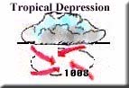
Tropical depression - An organized system of clouds and thunderstorms with a well-defined circulation and maximum sustained wind of 37 to 62 kilometres per hour (20 to 33 knots). |
|
| 2) |
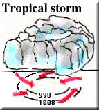
Tropical storm - An organized system of strong thunderstorms with a well- defined circulation and maximum sustained winds of 63 to 117 kilometres per hour (34 to 63 knots.) It is at this point that the storm is given a name. |
|
| 3) |
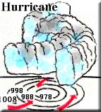
Hurricane - An intense tropical weather system with a well-defined circulation and maximum sustained winds of 118 kilometres per hour (64 knots) or higher. In the western Pacific, hurricanes are called "typhoons," and similar storms in the Indian Ocean are called "cyclones." At this stage, the storm has an "eye." |
|
Life of a Tropical Cyclone
 A Tropical Cyclone will progress through a series of stages from birth to dissipation. First, they begin as a tropical disturbance: a large area of organized thunderstorms that maintain their identity for more than 24 hours. If the area of thunderstorms organizes so that a definite rotation develops and winds become strong, the system is upgraded to a tropical depression. At this point, a low pressure centre exists (there is at least one closed isobar) and it is given a number.
If winds continue to increase to 63 kilometres per hour (34 knots), the system becomes a tropical storm and is given a name. The system now has several closed isobars at the surface. The storm becomes more organized and the circulation around the centre of the storm intensifies. As surface pressures continue to drop, the storm becomes a hurricane when wind speed reaches 118 kilometres per hour (64 knots). An eye develops corresponding to the lowest atmospheric pressure near the centre of the storm, with spiral rain bands rotating around it.
A hurricane will begin to dissipate when the conditions for tropical cyclone formation (see below) are taken away. When a storm passes over cooler waters it will begin to dissipate, as its main energy source, the warm ocean, is no longer there. Likewise, when a hurricane makes landfall, it will begin to dissipate because its energy source (the warm water) is missing. Since land is a rough surface, friction will slow down the movement of the storm, disrupt the low level inflow into the hurricane, and weaken the deep convection.
Tropical Cyclone Formation
Tropical Cyclones (known as hurricanes and tropical storms in the Atlantic Ocean, typhoons in the Pacific Ocean and cyclones in the Indian Ocean) can be a very powerful and destructive type of storm. This type of storm develops over oceans 8° to 15° north and south of the equator.
In order for tropical cyclones to form, there are several environmental conditions that must be present:
Hurricanes will not always form if these conditions are present. However, a hurricane will only form if these conditions are present.
Parts of a Tropical Cyclone
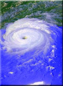
An intense tropical cyclone is an almost circular storm of extremely low pressure and high winds. Winds spiral inward at high speed, accompanied by heavy rainfall. Tropical cyclones can range in size from only a few hundred kilometres across for a small storm to over 1000 kilometres across for a monster hurricane. Tropical cyclones have three distinctive parts: the eye, the eye wall and spiral rain bands.
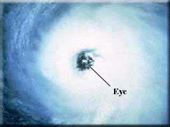 One of the most familiar parts of a tropical cyclone is the eye. The eye is located in the centre of the tropical cyclone and is produced by the intense spiraling of the storm. It is composed of air that is slowly sinking. As the eye passes over a site, the sky clears and calm prevails. Then, the storm strikes again with winds from the opposite direction. The eye is the region of lowest surface pressure and warmest temperature aloft. It has been found that the eye may be 10 °C warmer than the surrounding air at an altitude of 12 kilometres.
© Environment Canada, 2004
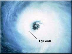 The eye of a tropical cyclone is surrounded by an eyewall. The eyewall is the area of highest surface winds in the tropical cyclone. It is composed of many strong updrafts and downdrafts. The mechanisms by which the eye and the eyewall are formed are not well understood, but it is generally thought that the eye feature is a fundamental component to all rotating fluids. Thus, it is similar to water that is going down the drain!
© Environment Canada, 2004
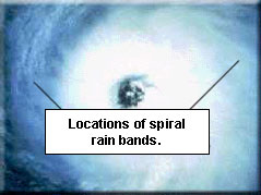
Hurricanes are surrounded by spiral rain bands. These are bands of heavy convective showers that spiral inward toward the storm's centre. Cumulus and cumulonimbus (thunderstorm) clouds ascend and lightning develops.
© Environment Canada, 2004
|
[Top] |